N&W’s client chose us to develop and document a process for collecting and evaluating projected mean daily precipitation from an ensemble of global climate models. This data was intended to inform Pennsylvania Department of Transportation (PennDOT) assessments of potential flooding vulnerabilities and climate risks related to transportation infrastructure. These assessments were intended to build upon PennDOT’s 2017 Extreme Weather Vulnerability Study and the hydrologic and hydraulic (H&H) assessments that are typically conducted by PennDOT.
The data source used for these analyses was the Federal Highway Administration’s Climate Model Intercomparison Project (CMIP) Climate Data Processing Tool 2.1, which utilizes expanded datasets from the Bureau of Reclamation’s Downscaled CMIP5 Climate and Hydrology Projections (DCHP) website. For this study, eight climate model projections were utilized to mitigate the influence of data outliers on the results
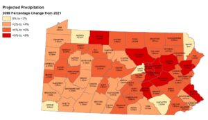
From this data, N&W compiled a statewide dataset of climate projections recorded at the county level. This dataset, comprised of over 4,000 datapoints, recorded the projected daily mean rainfall for the years 2021, 2049, and 2099, and calculated the differences in millimeters and percentages between each year. Analysis of the data conducted by N&W included the actual change, and percent change of the mean precipitation.
Project deliverables included tabular data representing the raw data from the climate models and analysis results, that same data in the form of a shapefile, and publication ready .pdf mapping.