Geospatial Solutions / GIS Projects
Custom GIS Tool Development
N&W was approached by a client with the need to join two region-level datasets with features numbering in the tens-of-thousands and no common fields to provide a basis for joining them together. The first dataset, an abstracted network of linked nodes representing actual roadways, contained traffic data. The second dataset was a “trueshape” representation of roadways and their associated travel time data stored in a shapefile. With no basis for the join besides their general location, a spatial match was the only option to merge these two datasets into one.
Consultation with the client indicated that this issue was not a unique occurrence and would likely be encountered in other regions when similar traffic analysis was to take place. Instead of simply developing a method to join the data for this instance, N&W and the client agreed that the development of a custom GIS tool that could automatically complete the complex task in a manner that could be applied to this and any other two datasets with the same limitations.
A custom python script was created that joined the two datasets based on variables including feature location, bearing, and path of travel. Customizable variables within the script were also created to adjust the sensitivity of the feature matches so the script could be tuned to provide accurate results for other datasets in the future.
In just a few weeks, N&W was able to provide our client with a custom, repeatable, automated solution to join the two datasets, where it would take an estimate of over one thousand hours, if done by hand.

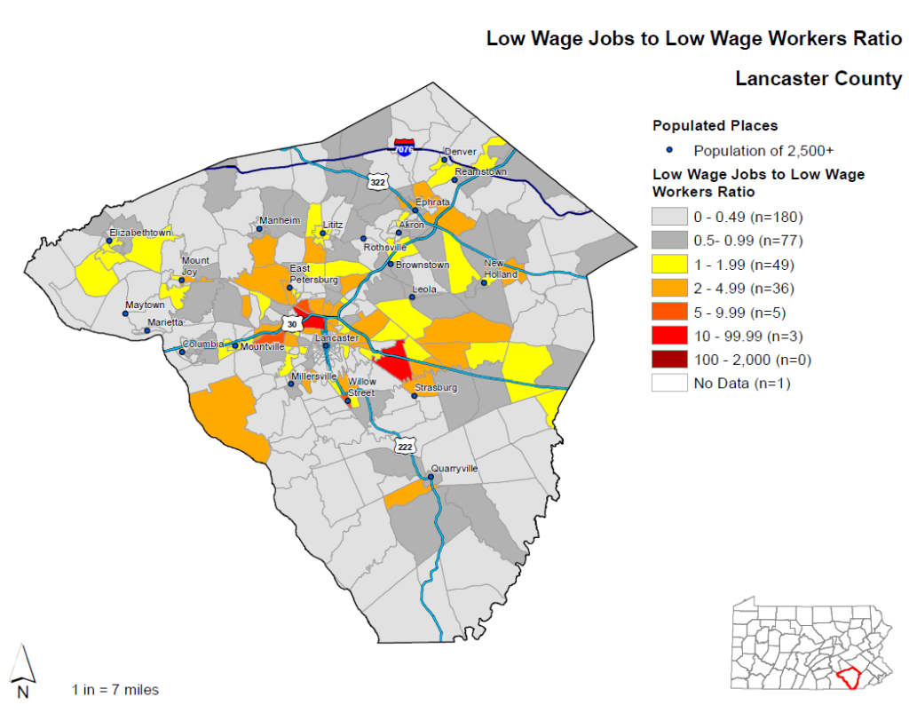
Statewide Public Transportation Need Study
A client studying public transportation across the commonwealth of Pennsylvania sought out N&W to develop a statewide dataset of economic and demographic data to assist with the identification of locations in each county that would be best served by an increase in public transportation options.
The dataset developed by N&W analyzed statewide demographic and economic data down to the census block level (421,545 census blocks in total). Analysis, at the direction of the client, involved the calculation of the ratio of jobs classified as low wage to workers living within the same area. Areas with a higher number of low wage jobs and fewer low wage workers were determined to be an indicator of the need for public transportation by the client – an indicator of individuals with unwalkable commutes who may be burdened by non-public transportation methods.
N&W developed the requested dataset and deliverables to the client consisted of tabular data, shapefiles, and a package of presentation-ready maps for each of the 67 counties in Pennsylvania.
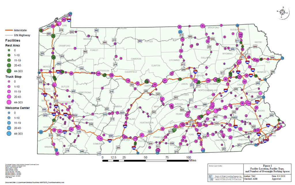
Statewide Air Pollution Contribution from Idling Diesel Trucks Study
The overnight idling of diesel engines on tractor trailers at truck stops is a known significant contributor to air pollution. N&W was contacted by a client who needed a reliable and up-to-date dataset of overnight parking spaces at rest stops covering all of Pennsylvania to aid in their study of statewide pollution.
After discussing the project needs with the client, N&W developed a methodology for gathering the necessary data through a combination of crowd-sourced data covering locations of business in the state, examination of aerial photographs, and old-fashioned cold calls to truck stops asking how many overnight spaces they had on site.
N&W knew we had to complete the collection of the data (ultimately measuring 10,000+ individual data points!) within the client’s aggressive schedule. With it’s staff of GIS analysts, as well as it’s numerous other technical staff who were able to be brought onto the project, N&W was able to provide the requested deliverables to the client within the requested time-frame.